Matt Begg and Alysha Edwards

The dog days of pre-contact BC

Many years ago, early in my (Matt Begg’s) career as a professional archaeologist, I was sitting around a campfire with a couple of colleagues, one of whom was an accomplished faunal analyst (someone who analyzes bones, or fragments of bones, found at archaeological sites).

I asked my colleague about dogs, specifically, what did the average village dog in the Southern Interior of British Columbia look like?

He pointed at my medium-sized, mixed-breed brown/black/tan/white dog and said, “Probably a lot like him.”

Many of us have heard about some of the specialized dog breeds in pre-contact B.C., such as the Salish hair dog, but we don’t hear much about the average, run-of-the-mill village dog that was living alongside, or with, the pre-contact inhabitants of our region.

I’ve always had somewhat mixed-breed dogs — the good-to-a-free home or sprung-out-of-the-pound variety. They’ve always been medium-sized and somewhere between one breed or another.

Is this what the village dog looked like? Were they anything like the Sadies, Fidos and Bellas we know and love today?

Domestic dogs have been identified in archaeological sites around the world. Research looking at dog remains excavated from pithouse village sites along the middle Fraser River, near Lillooet, indicates their presence alongside people during the last 2,000 years at least, though we can assume for much, much longer.

At the Keatley Creek site, for example, the remains of at least 15 domestic dogs were uncovered during academic investigations (Crellin and Heffner 2000:162).

In a recent publication, the function of dogs in mid-Fraser village sites are hypothesized under four categories: hunting aids, sources of labour, indicators of wealth or free roaming.

The archaeological evidence is compared to ethnographic descriptions and some broad conclusions can be made.

Free-roaming village dogs were likely ubiquitous in pre-contact villages, serving as refuse cleaners (think of any food you drop on the floor or disposal of waste products), warnings of nearby dangers (I have a dog that warns me about approaching snowplows) and, likely, as companions.

Ethnographies in the middle Fraser describe dogs as forms of wealth, providing dog hide clothing, dog skin quivers and sources of meat. The use of dogs as labourers is not well documented in the archaeological record, but at least one set of dog remains found at the Keatley Creek village site suggests it may have served to pack goods, such as hauling fish up from the river (Prentiss et al. 2021, Crellin and Heffner 2000).

Although there is still some uncertainty surrounding what those free-roaming village dogs would have looked like, the excavated remains of Canis familiaris in middle Fraser village sites show a distinction between domesticated village dogs and wild canines (wolves and coyotes).

Notably, village dogs are described as being smaller than wolves, but more robust than coyotes, with shorter muzzles than their wild relatives.

We can’t know for sure what these dogs looked like, but we suspect their genes continue to be passed down through modern dogs.

Whenever I’m at a dog park, I overhear conversations about dog breeds — the particular modern breeds that fit into narrow categories or suggestions about the various breeds that went into creating the mutts to which I am drawn.

Whenever I watch my dog clean up after a campfire or warn me about nearby wild animals (or snowplows), I wonder if she might be, at least partially, a descendent of the village dogs of the past.

Alysha Edwards is a St’at’imc archaeologist currently at graduate school at the University of Montana and Matt Begg is a Kamloops-based archaeologist. Interested in more? Go online to republicofarchaeology.ca.

Ashes to ashes through the centuries

In our column in May, we discussed prehistoric use of the upper Bridge River by St’át’imc peoples and the volcanic eruption of Mount Meager that covered the valley in blankets of Bridge River Ash approximately 2,400 years ago.

As described in the last column, scatters of stone artifacts are abundant along the Downton Reservoir in the upper Bridge River Valley. However, the sites are out of context, making it difficult to distinguish between sites used before and after the Mount Meager eruption. While habitation sites (such as the Bridge River village) are absent in the middle and upper Bridge River Valley archaeological record, diagnostic tools and lithic scatters provide indicators on how and when this resource rich landscape was used and occupied.

A short distance downstream from the Downton Reservoir is the Carpenter Reservoir, stretching from near the town of Goldbridge to approximately 47 kilometres downstream to the Terzaghi Dam. Similar to the Downton Reservoir, Carpenter Reservoir is covered by Bridge River volcanic ash, though the ash deposits are not as thick as the deposits observed farther upstream.

Archaeological surveys over the last few years by St’át’imc Government Services (SGS) have found frequent scatters of stone artifacts along both banks of the reservoir. Volcanic ash layers can be useful for archaeologists, as archaeological sites occurring below ash layers can be confidently determined to be older than the eruption, while those above the ash layer are more recent. The changing environment of reservoirs make this impossible, as the ash tends to move up and down in the water column and collect on low-lying lands at high pool.

Unlike sites we described at the Downton Reservoir, several archaeological sites found during surveys of the Carpenter Reservoir included temporally diagnostic artifacts. The method of relative dating stone tools has been discussed in previous Dig It columns, but as a refresher, based on stylistic attributes, certain tools and points can be associated with specific dates as “horizon markers” by comparing them to other projectile points found in dateable contexts (like systematic investigations with secure carbon dates).

So far, dateable artifacts found along the Carpenter Reservoir can be assigned to time periods between 3,500 and 200 years before present.

At one archaeological site that is densely packed with stone artifacts, projectile points from the Shuswap Horizon (3,500-2,400), the Plateau Horizon (2,400-1,200) and the Kamloops Horizon (1,200-200) were found scattered on the surface amidst drifts of volcanic ash. At another site a bit further downstream in the reservoir, six diagnostic projectile points were identified that span the same time periods, and a third site includes points from 3,500-1,200 years before present.

Projectile point styles don’t change overnight, and while we can’t be certain of how long after the Mount Meager eruption it took for people to return to the middle Bridge River, it’s clear that particular locations were well used before and after the eruption. Due to the exposed nature of the reservoir, secure carbon-dating samples would be difficult to find. Future investigations will hopefully discover archaeological sites in undisturbed contexts outside of the exposed reservoir, where we can determine depths of artifacts relative to the volcanic ash (buried below the ash means older, whereas above the ash means more recent) or collect secure dating samples.

Archaeological sites can represent a single-use occupation, or repeated and continual use of a landscape over time. Based on the artifacts found in the upper and middle Bridge River Valley, it’s clear this landscape was subject to continual use by St’át’imc for millennia.

As we encounter our own modern catastrophic climate events, it’s useful to remember that humans have survived past devastating events and thrived, but they did so out of necessity, whereas we have choices.

Alysha Edwards is a St’át’imc archaeologist and graduate student at the University of Montana. Matt Begg is an archaeologist based in Kamloops.

A river of ash nets historic catch

Approximately 2,400 years ago, Mount Meager, in the Southern Interior of British Columbia, erupted.


The eruption launched a plume of ash that was deposited on lands up to 530 kilometres to the east, in southern Alberta.

Directly downwind of the eruption is the Bridge River, from which the massive deposits of ash get its name — Bridge River ash.

More recently, the landscape of the upper Bridge River is one that has been modified by modern dams, impounding the Bridge River in two reservoirs.

During the last five years, St’át’imc Government Services has conducted archaeological survey work in the upper Bridge River, looking for archaeological sites both above and below the deep layer of ash deposited by this eruption.

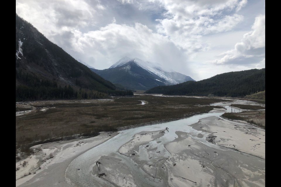
The landscape we’ve encountered is both breathtakingly beautiful and a reminder of the destruction that occurs with a massive volcanic
eruption.

When Mount Meager erupted, it left a thick layer of ash in the Bridge River valley, likely killing much of the forests and animals in its path.

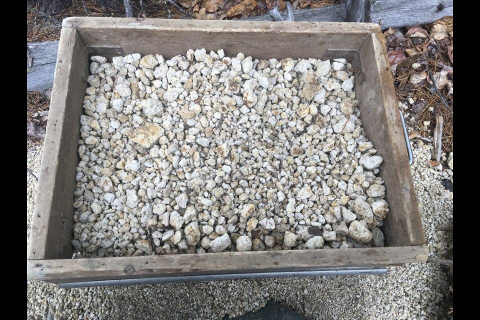
The river is full of volcanic tephra, both in a talcum-like powder form and popcorn- to fist-sized chunks of pumice. Eroded hillsides show rivers
of ash.

Reservoir archaeology can be fascinating.

When you remove all the normal impediments to finding archaeological sites, like forest littermats, soils and surface sediments, artifacts can be found  on the surface.

Due to the land exposure in reservoirs, we don’t necessarily need to dig to find buried artifacts, which can be time-consuming and provide only a narrow glimpse into what is present beneath the surface.

The sites are out of context and disturbed, but we tend to find more than we would if we depended on the usual subsurface testing.

However, when the landscape is covered in volcanic ash and silts are drained from a massive glacier, things get a bit trickier.

Subsurface testing adjacent to the Bridge River in forested settings has shown that up to a metre of ash is present beneath the forest floor.

When we’ve excavated shovel tests in these contexts, we’re digging to the depth of our shovels and scooping out bucket-fulls of ash.

Again, you have to picture what it would have been like to be in this river valley when the eruption occurred — scary and, most likely, deadly.

Despite the thick deposits of ash, we are finding abundant archaeology.

Due to the modified landscape and the thick blankets of ash, we aren’t certain if any of the archaeological sites we have identified pre-date the

Mount Meager eruption, but it is clear the upper Bridge River was (and still is) well used by St’át’imc peoples.

Archaeological sites composed of stone artifacts and tools are present on alluvial fans and slopes bounding the Bridge River and we can assume this has always been true.

We’re hopeful to find dateable artifacts and to develop the means to test below the thick layer of ash more effectively, but it seems certain that St’át’imc peoples utilized the resources in this river valley.

Since the volcanic eruption, the Bridge River valley has rebounded with lush, high elevation forests and abundant wildlife.

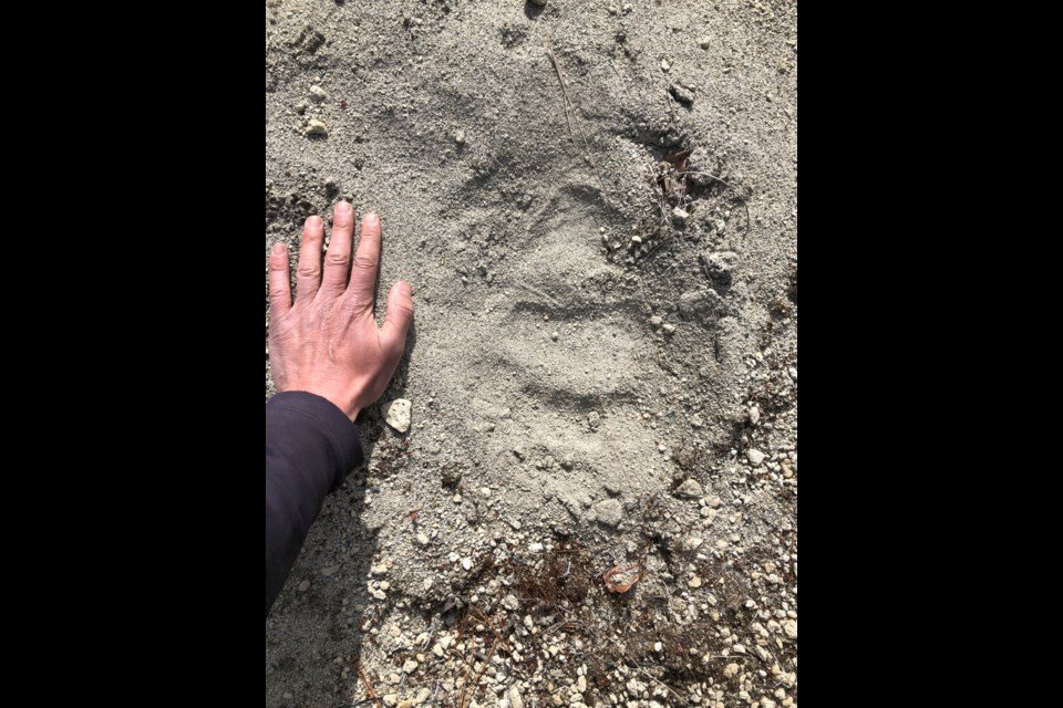
Footprints in the ash show a thriving grizzly and black bear populations, as well as wolves, deer and moose.

Fish are present in the river and eagles are perched above the river looking for these fish.

While this river valley faced a natural disaster and modern impacts from dam construction, it’s clear from the archaeology in the upper Bridge

River valley that St’át’imc peoples were adaptable to changing environmental conditions and have much to teach during our continuing climate changes.

Alysha Edwards is a St’át’imc archaeologist and graduate student at the University of Montana. Matt Begg is an archaeologist based
in Kamloops.