Abby Wilson

The Many Hats of an Archaeologist

An archaeologist working in cultural resource management in British Columbia has to wear a lot of hats (and no, I’m not referring to the stereotypical Indiana Jones hat). It can be exciting to learn many skills, and it allows for considerable variety in day-to-day tasks.

Some of the hats we wear (and we don’t proclaim excellence or expertise in these fields):

The hat of a labourer. In order to find out what is under the ground, archaeologists must dig shovel tests, or excavate evaluative units. Shovel tests are less precise, and often measure 35 cm by 35 cm to depths of between 50 cm to 70 cm, which can be a laborious task. The soil removed must also be screened to find artifacts. Evaluative units may be excavated slowly with a trowel, centimeter by centimeter, or a bit faster while shovel shaving, 5 cm to 10 cm at a time, which combines labour and precision.

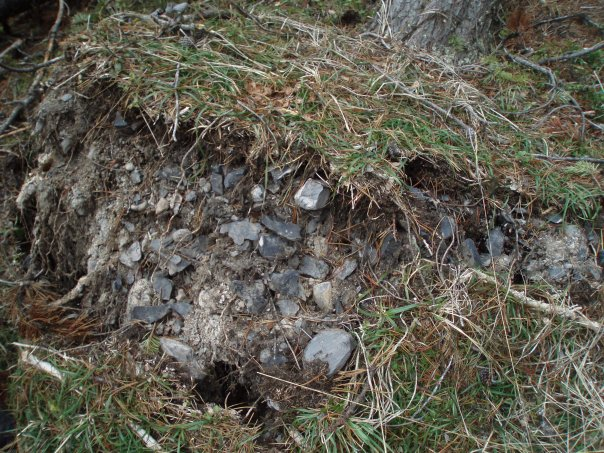
The hat of a geologist. Archaeologists have to describe the stratigraphy in subsurface tests and evaluative units to try and determine what geological layers are present. This can tell an archaeologist what type of soil artifacts come from, and where to possibly expect them in the surrounding area. Layers of soils and rocks may give a timeframe of the when the layer was created, such as glacial till from the glaciers melting or a layer of volcanic ash from a well-known volcanic eruption (see photo 1).

The hat of a cartographer. An archaeologist may need to read a map to find out where they will be working. Although GPS units and other digital navigation alternatives make locating work areas and previously recorded sites easy, it is still important for an archaeologist to know how to read a physical map. This can help identify areas on the landscape with a higher probability for archaeological sites, such as locations near water sources. Archaeologists must also draw maps while in the field, of places where they have completed shovel testing, as well as site maps, when archaeological material is encountered. They use a compass and measuring chain to illustrate a scaled down map, which includes shovel tests, evaluative units, trees, boulders, landform features, water sources, and a number of other helpful identifiers (see photo 2). The maps must also be legible for other archaeologists to read and decipher.

The hat of a leader. An archaeology crew can include anywhere from a couple to a dozen or more individuals. The field director or field supervisor is in charge of the safety and coordination of the crew. They must plan routes to and from the site, communicate with project managers or clients, ensure a safe work environment for all crew members, and track productivity to stay on target with timelines. They must also listen to input from the rest of the crew, and uphold the standards expected of professional archaeologists in BC.

There are many more hats an archaeologist can wear in the span of their career, and each individual has their own assortment of skills. Cultural resource management can allow for changing work areas, a variety of tasks, new crew members, and never-ending learning experiences. People are always discovering new things, and our understanding of history is likely to continue to evolve. That takes many hats, and I’m always looking forward to finding out which one I will wear next!


Microblade was a prehistoric toolbox

There are many different ways to turn a rock into a useable tool. The most commonly recognized rock tool, referred to as a lithic tool, is an arrowhead style projectile point. This lithic technology can take a considerable amount of effort, and a large rock, to create. There are many lithic tools made for quick use, which involve much less preparation, time, and effort. These are referred to as expedient tools, and one of these tools is the microblade.

In Photo 1, you can see the largest artifact in the top left - this is a microblade core. The remaining 13 artifacts are different sizes of microblades – some broken and some whole. Microblades are removed from the microblade core with a length at least 2.5 times longer than they are wide. They have parallel edges, and on one side you can see the places where previous microblades or flakes were removed, called scars. The cores exhibit long, narrow microblade scars and often are shaped like a cone. Photo 2 gives a good visual of the 4 sides of a microblade, as well as the typical ‘cone-shape’ of a microblade core.

According to research, microblades were first used in northeast Asia. The technology was brought over to North America by way of Beringia, the Bering land straight, to modern day Alaska. Dating back to 11,600 BP, evidence from Swan Point, Alaska indicates some of the first people to enter North America brough the microblade technology with them. This hypothesis is based on similarities in the methods that the microblade core is made into the individual microblades, called ‘core reduction strategy.’

After making its way into the northern end of North America, the microblade lithic technology continued to expand to the south, where it has been observed in a wide time span of archaeological contexts, covering the entire prehistoric period in British Columbia. These observations are made when microblades are found with materials or technologies which can be connected to a specific range of years.

One study looked at a number of microblade sites and their locations, and it was noted that microblades were more frequently found in higher concentrations in temporary, upland campsites. This led to their conclusion that microblade technology made for a toolkit that was flexible, versatile, and easy to adapt while moving frequently with unpredictable tool needs. It was also transportable, and much lighter than the larger rocks required to make bigger tools or arrowheads.

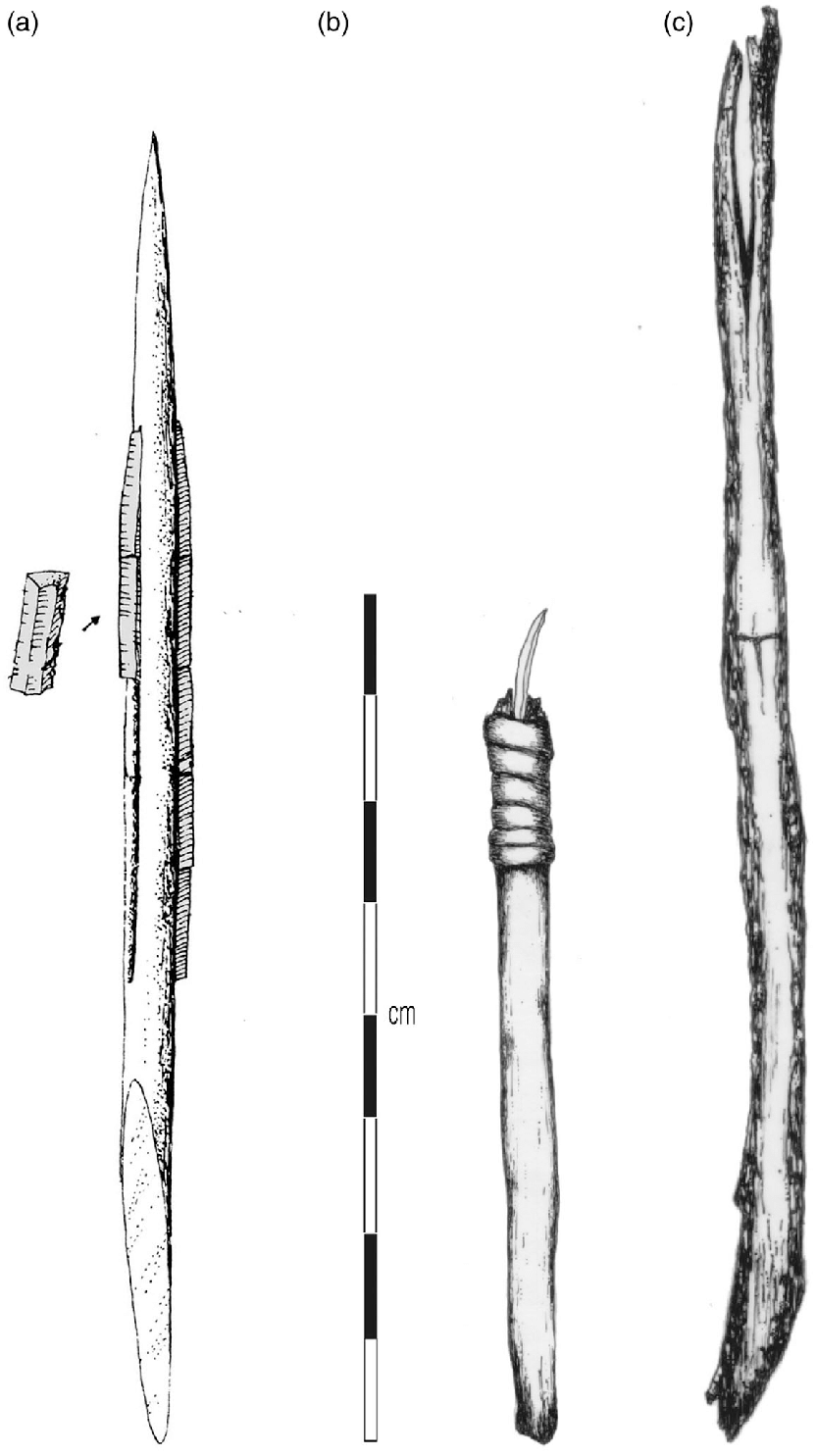
A looming question on microblades that could still use more research is what they were used for. A number of theories currently exist, and the ones shared here are by no means an exhaustive list. Microblades have been found as hafted tools, meaning they were attached to a handle made of antler, bone, or wood. At a site in Washington State where a collection of hafted microblades were recovered, both side hafted and end hafted knives were identified (Photo 3). This means that the blade was attached to the end of a handle, making it more of an engraving style tool, as well as to the side of a handle, making it into a cutting style tool.

Microblades have many attributes which make them useful in a variety of tasks. They have been observed all over British Columbia, including around the Kamloops area, and continue to be discovered as archaeological excavations continue. I was involved in an excavation this fall within an hour’s drive of Kamloops, where the crews found X3 of microblades.  Analysis is currently underway, and we are excited to see how they fit into the archaeological record, and how they compare to what is already known about this fascinating technology.

Perusing projectile points of war

Whenever I see a projectile point, I am always impressed with the level of detail and time that went in to turning a plain rock into a useable tool. While working in the Big Bar locality on the Fraser River, a considerable number of multi notched, or serrated, projectile points were recovered, leaving me even more amazed by the meticulous work put into these tools. Why did the makers begin taking the extra time and effort to put serrations on the projectile point, after thousands of years without? (Warning – this contains some unpleasant details).

Projectile points in the Canadian Plateau of British Columbia are assigned to archaeological time units using specific size and shape characteristics. The age ranges are determined through carbon 14 analysis of datable materials found in association with the same point styles in other archaeological sites.

The most recent archaeological unit is the Kamloops Horizon, which dates from 1200 to 200 years before present. The characteristic projectile points from this Horizon are typically small (1.5 to 3 cm long), thin, and triangular in shape. Larger points became more frequent towards the recent end of the time period. The points have 2 small opposing U shaped notches above the base, and are predominantly produced from fine grained volcanic rock such as basalt and dacite. Photograph 1 shows a typical Kamloops Horizon point. The multi notched variation of the Kamloops Horizon point has 2 or more deep, narrow, U shaped notches along one blade edge. This style has been found in the Mid-Fraser and Thompson drainages in sites dating from 600 to 200 years before present. Photograph 2 shows an assortment of complete and fragmented multi notched Kamloops Horizon points collected from a notable site in the Big Bar area.

Although more in depth research is still needed, it has been theorized that multi notched projectile points may have been designed for use in serious interpersonal conflicts. The extra notches would result in greater damage during arrow penetration, and would also cause more damage when removed. The notches on a thin projectile point make it more prone to breaking, either on impact or extraction, which would leave the tip of the point in the wound. This may promote infection or require invasive removal, resulting in further physical damage.

Secwepemc oral histories, along with ethnographic record, reference inter-regional conflict and tensions between nations, and that the Fraser River and Plateau was an area with significant conflict and overlapping territories. Hunting and fishing grounds could have been the subject of social conflict, and sections along the Fraser River still have assigned fishing rights today. Multi notched projectile points were utilized just prior to the arrival of settlers, and the introduction of colonial weapons may have resulted in a shift from stone tools for conflict. As addressed in a previous Dig It article, a metal projectile point was also recovered in this area, which may be correlated with the timeline of the arrival of settlers and the introduction of new arrow material with the potential to cause greater injuries.

To have made the shift from tools manufactured for means of subsistence through hunting and gathering to a weapon of warfare is part of a shift of lifestyle and inter-regional group dynamics. What kinds of shifts in society took place for this to occur, and what caused certain groups to aim to make war on others? Oral histories and ethnographic accounts are our best way to gain understanding of the societal interactions, and the archaeological record will hopefully help instigate and continue those conversations and research.

Every layer is a story centuries old

Do you ever drive through the Southern Interior and admire the landscape of the valley, looking at the layers of stratigraphy in the steep drops cut into the hills along the rivers? Every layer on those hills tells a story, and can even help associate a depth in the ground with a place in time.

The latest major glacial period, the Fraser Glaciation, began before 25,000 Before Present (BP, with present being 1950), reached its maximum extent about 19,000 to 15,000 BP, and ended with rapid ice melting and evaporation around 14,500 BP. During this melting, the Cordilleran Ice Sheet covering British Columbia broke into several large masses which became stranded in lower areas of the interior. Movement of the melting glaciers left behind landforms such as drumlins, which indicate the direction of flow. The glaciers cut into river valleys, incising steep ravines and molding undulating landscapes, while depositing glacial till as it moved and melted. This glacial till is composed of unsorted rocks ranging from small pebbles to large boulders, and soils such as sand or clay. This sediment layer is important in the archaeological procedure.

We know the southern interior was under an ice sheet for millions of years, and evidence of human occupation dates back to at least 14,000 BP, following the end of last ice age. If archaeologists are digging test holes and encounter a layer of glacial till, they can typically deduce that cultural material will not be found below that depth. However, one instance that is not the case is when a landslide transports a wide range of materials, including glacial till, and covers a natural landscape. Another example is where ground disturbance occurs from machinery, displacing sediments and disturbing their natural layers. In these scenarios, an archaeologist takes into account the surrounding landscape and ground disturbance that has occurred. They can also dig a percentage of tests deeper into, or through, the glacial till to confirm a natural deposition rather than an accidental deposit.

When you look at exposed soil in areas such as the Kamloops Bike Ranch, you see different layers of stratigraphy. Some sediments travelled there by water, air, or gravity. Archaeologists let the soils tell them a story of how that landform came to be formed, and from this story, try to figure out a timeline of deposition of cultural material. In some instances, multiple layers of occupation over a range of depths will be found at a single location, which is possible due to sediment displacement from the forementioned processes (water, air, and gravity), which cover the older layers of occupation, making new habitable locations.

Another part of sediment layers that help relate a depth in the ground with a place in time is the presence of volcanic ash- for example, the Mazama eruption, which has been dated to approximately 7600 BP. Volcanic eruptions can provide a chronological framework for archaeologists because they can be dated to a specific time in history. One can assume if artifacts are found below a particular volcanic ash layer, which is a fine white powdery lens, they would have been deposited before that eruption.

Next time you drive from Kamloops to Monte Creek, look at the layers exposed on the hills, and see if you can find the glacial till or the volcanic ash- or just enjoy the view of thousands of years of history. Now that I know more about the temporal aspect of soils, I appreciate the natural landscape with a new perspective, and I hope you do too!

Archaeology in the Forest

When many people think of archaeology, they think of large excavations and activities which involve the ground – digging, trowelling, and uncovering history below us. In British Columbia, a lot of archaeology that is done is a result of industry, and one industry which many archaeologists work in is forestry.

 When a forestry company has blocks they plan to harvest, one of the steps they must take before they can begin is to involve cultural heritage organizations. Crews usually consist of an archaeologist and members of local First Nations. Maps will be acquired, archaeologists will do background research to find registered sites in the area of work, if present, and make a plan. Then the crew will visit the blocks and do ground survey.

 This is called a preliminary field reconnaissance, or PFR. This entails crew members walking the cut block in transects of specific, but variable, distances, depending on the requirements or desires of the organization. Sometimes the blocks have been previously harvested, and are easy, casual walks in the forest. Other times, the blocks have heavy deadfall due to beetle infestation killing trees, poor forest management, or many other reasons. Forestry work involves hiking many kilometers a day, in remote areas with obstacles such as wildlife, danger trees, and old forest service roads no longer passable.

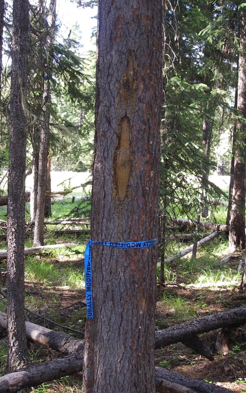
 While in the forest, the crew is looking for culturally modified trees, or CMTs. They can be trees with various stages of scarring left from the past when indigenous peoples would cut into them for a variety of reasons- marking trails or harvesting bark for example. In the interior, old growth trees have mostly been harvested, and therefore unfortunately so have many of the CMTs. According to the Heritage Conservation Act, CMTs must be culturally modified before 1846 to be deemed protected. There are various methods used to try to deduce the age of the tree and time of modification; using an increment borer can give the archaeologist an accurate age.

 The crew is also looking for surface artifacts (which are exciting but can be rare to find on the forest floor due to a lack of surface exposure), cultural depressions, or landforms with archaeological potential. Cultural depressions can identify a house pit, cache pit, or fire pit, depending on the shape and features of the depression. Landforms of archaeological potential can be anything from breaks in slope where someone would like to sit and work on a stone tool while hiking, to a low-lying terrace beside a creek to spend time fishing and having a fire, to a high ridge with rocky outcrops to watch over the valley looking for animals to hunt.

 The crew will identify the areas or trees within the cut block deemed to have archaeological significance, and will generally recommend avoidance as the method of mitigation. In many cases, the forest company will exclude those areas from the final harvest plan. If they chose not to, they would need to obtain a Heritage Conservation Act permit to then assess the areas with an archaeological impact assessment to identify and evaluate sites.

Hiking through the forests can be a fun way to spend the workday, imagining how the land may have been used in the past and finding clues to point us there. If you are ever hiking in the forest, and you see an artifact lying on the trail, leave it where it is. Take a location identifier and contact the archaeology branch – you may have just discovered a new site!

Call Before You Dig: Understanding BC's Heritage Conservation Act

As an archaeologist, the Heritage Conservation Act (acronym HCA, or sometimes just referred to as the Act) is the main guide to what I do. Similar to many legislative documents, it is a bit overwhelming and tedious to read, but vital to understand. Every province has their own version of the HCA, so one must be aware of the provincial regulations specific to their work environment.

Creating regulation for the conservation of heritage property in British Columbia started back in the 1860s. At that time, archaeological processes were focused on colonial regulations, and were not developed in consultation with First Nations. In the 1960s, new regulations were created, but the collaboration with First Nations was still absent. Following the rise of Cultural Resource Management in the early 1970s, the first version of the HCA we know today was written in 1977 and is currently administered by the BC Archaeology Branch. In 1987, First Nations were finally involved in the changes to the HCA. The most recent changes to the HCA took place in 2019, after 20 years with no revisions.

The purpose of the Act is to encourage and enable the protection and conservation of heritage property. Heritage property is a designation applied to land which the Ministry of Forest, Lands, National Resources Operations and Rural Development (FLNRO) deems to have heritage value – the historical, cultural, aesthetic, scientific, or educational worth or usefulness of a site or object. Locations with evidence of past use that pre-date, or are assumed to pre-date, 1846 are protected under the Act, and some sites, such as human burials or shipwrecks, are protected regardless of age.

There are various ways of determining if a property has heritage value. There is a government run database called Remote Access to Archaeological Data (RAAD), which archaeologists, First Nations, and industry representatives can apply for access. The database comprises an interactive map containing all archaeological sites that have been registered with the Archaeology Branch through the submission of ‘Archaeological Site Inventory Forms’.

For areas where no data has been collected, a heritage inspection or investigation may be required. This is to assess the archaeological significance of the land, determine the presence of archaeological sites, and recover information that might otherwise be lost through alteration or destruction. In order to carry out the inspection or investigation, an archaeologist has to obtain an HCA permit from the Archaeology Branch. In the vast majority of cases, the permit must be held by an archaeologist meeting specific professional standards. These permits have an extensive list of requirements, following strict guidelines outlined in the HCA. If a site has been identified and cannot be avoided during development, a Site Alteration Permit must be obtained, which authorizes modifications to the archaeological site.

One of the biggest changes to come about in 2019 was the requirement to have heritage inspections conducted if deemed necessary by the minister. This means that more areas are required to have a heritage investigation conducted before commencing land disturbance. The proponent (individual or company) requesting the alteration of land is required to pay for the cost of the heritage investigation. Another change is the enforcement of consequence for the disregard of the HCA. There are now written penalties, power to obtain warrants, application of stop work orders, and the ability of to suspend or cancel permits, among other methods, to enforce the regulations in the HCA.

Heritage property is a non-renewable resource. Once it is destroyed or altered, we lose context and information, artifacts are destroyed, and cultural heritage is lost.  Now that you understand a bit more about the rules, I encourage you to call before you dig – an archaeologist, that is. Help us mitigate the destruction of the thousands of years of history, hiding just below the surface.